Introduction
Mount St. Helens is a volcanic mountain in the Cascade Range in Western North America, in the state of Washington. It is, perhaps, the most famous mountain in the range, and certainly is the most active volcano in the area today. In fact, it has probably been the most active of the Cascade volcanoes for over 4000 years.
If the eruption of 18th May 1980 follows the pattern of previous eruptions the mountain will remain very active for perhaps ten or twenty years before beginning to quieten down again.
The 1980 eruption was the first time that it was possible to use modern technology to carefully monitor a volcano as it built up towards a violent eruption. Scientists gathered vast quantities of data about the mountain in the months that led up to the eruption, and were able to record events as they happened. Despite this, the precise moment of eruption was impossible to determine beforehand, and caught the researchers by surprise.
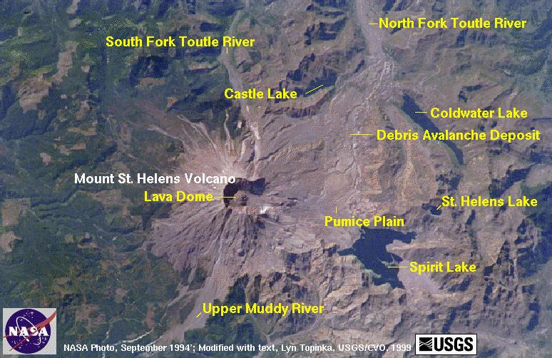
The prediction of volcanic eruptions is difficult, although most scientists studying them, volcanologists , would say that it can be easier than predicting earthquakes. The location of Mt St Helens and key places around it are shown in the satellite image below.

History
The Cascade mountains lie along the western coast of the United States. This area is one subjected to frequent earth movements and has a long history of volcanic activity. The mountains have formed as a result of seismic activity. The American coast is part of the North American Plate; the Pacific Ocean to the west overlies the Juan de Fuca plate. The Juan de Fuca plate is being subducted below the North American plate by processes explained by the theory of Plate Tectonics. As the descending Juan de Fuca plate is subjected to increasing pressure it becomes hotter and begins to partially melt. The molten rock, called magma begins to rise towards the surface. When it reaches the surface it erupts and a volcano is formed. Mt St. Helens is the youngest of the volcanoes in the region, being a mere 2,500 years old, but the area has been volcanically active for almost 40,000 years, hence the large number of volcanic mountains forming the Cascade Range.
The Build Up To The 1980 Eruption
Mt St. Helens had been quiet, or dormant , for 123 years. On 20th March 1980 a series of small earthquakes were detected in the region and volcanologists started to become interested in the mountain. During the following few days the magnitude and frequency of the shock waves began to increase, then the first small eruptions began. These consisted of releases of steam and ash. This was the cue for the scientists to begin regarding the mountain as a serious potential hazard.
The United States Geological Survey
began issuing warnings to people living in the area, and briefed the Forest
Service. They, in turn, began to close access roads into the mountains and
to clear the surrounding area of tourists and 'non-essential' personnel.
These early actions were a calculated risk. As always there was a balance to
be made between warning and protecting people, and causing panic or issuing
a false alarm. Undoubtedly though, thousands of lives were saved by the evacuation
and closure of the area.
Geologists installed highly sophisticated equipment on the mountain. They constantly monitored the chemical composition of groundwater and escaping gasses, they used laser surveying techniques to look for any expansion of the ground, and recorded the constant seismic activity.
The side of the mountain was clearly beginning to expand as pressure began to increase. By late April there was a bulge 1000m wide and over 2000m long. It was rising at a steady rate of about 1.5m every day as the mountain began to fill with magma being forced up from below.
The gas eruptions were also being very carefully monitored. Erupting volcanoes give off large quantities of sulphur dioxide gas, SO2 (the one that smells of rotten eggs ), so any increases in the emission of this gas might have suggested an impending eruption.
The Eruption
The volcano seemed to quieten down during mid May. Saturday,17th May saw only 18 recorded earthquakes in the region, less than half the daily value of the previous days. Sunday morning was very quiet, hardly any seismic activity, and reduced gas eruptions. At about 8.30 am a research scientist, David Johnston, was working at an observation station about 8km away from the main crater. He had been monitoring gas emissions and watching the mountain whilst in contact with his base,Vancouver, via a two way radio. He transmitted a short message "Vancouver!,Vancouver!,This is it". Moments later he died as over 4km³ of rock, gas and steam exploded from the northern side of the mountain.
The eruption has been started by an earthquake with a magnitude of 5 on the Richter Scale . The surface of the northern side began to move downhill. As it moved, the pressurised magma was able to explode outward through the weakened area. The blast was equivalent to 500 times the power of the atomic bomb that flattened Hiroshima. As it moved outwards it flattened an area of mature forest roughly 35km by 20km. Trees were pushed flat pointing away from the source of the blast. Such was the speed of the moving air and debris that it overtook cars as people tried to escape.
The initial explosion was followed by further problems as ice and snow on the mountain was converted to superheated steam. This combined with ash to produce fast flowing mudflows which swept down the mountain into the Toutle River, which at one stage was heated to 90°C.
The mudflows moved through houses picking up cars, trucks, trees and even whole buildings. The collected debris was carried downstream where it smashed into river defences and bridges. As the mud settled in the Columbia river it reduced the depth in places from over 12m to neared 4m, trapping large boats upstream of the shallows.
Other ash, not cooled by water, moved away at speeds up to 130km per hour. These ash clouds, at 500°C, burnt everything in their path, before settling out around Spirit Lake. As the deposits built up they blocked the exit from the lake causing the water level to rise by a massive 60m and trigger fears of another disaster waiting to happen.
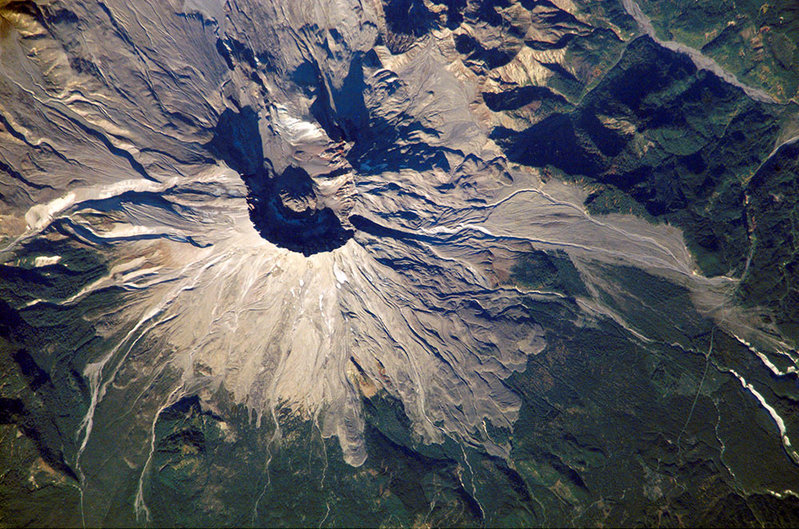
Ash which was thrown vertically into the atmosphere was found over 15km above ground level. As time passed the ash spread out and by the 5th June had traveled right around the Earth. The image below, taken from the Space Shuttle, shows the devastation as it looked in 2002, twenty years after the eruption.

Despite the magnitude of the disaster, in true American style, a local business saw a unique marketing opportunity. The ash which fell on the local towns was gathered up and heated in kilns before being molded into 'Genuine Mt St. Helens Ash Trays'!
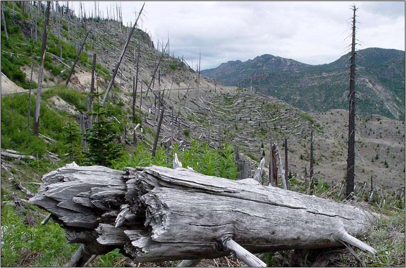
Today, the area still shows scars of the explosion, but vegetation is returning to the area. As you can see from the photography below, by 2003 there were still vast areas of bare rock debris. Replanting by the Forest Service has helped mixed vegetation re-establish itself in selected areas, but steeper slopes remain bare.

![]()
