Continental Drift and Plate Tectonics
Continental Drift
 As far back
as 1620, Francis Bacon spotted that the west coast of Africa and the
east coast of South America looked as if they would fit together, like
pieces of a jigsaw puzzle. Between then and 1912 other people identified
further similarities between other continental coastlines, but it was
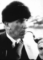
only in 1912 that Alfred Wegener (left) published a theory to explain
why the Earth looked like a huge jigsaw puzzle.
He suggested that a very long time ago all the land that covered the Earth had been joined together into one huge continent. He named this landmass, Pangaea, and suggested that millions of years ago this supercontinent had somehow broken up. The different parts had then drifted into the present day positions.His evidence for this was drawn for several sources, covering geology, biology, geography and other sciences.
Firstly, he was able to show that fossils of a small reptile called Mesosaurus were found only in South Africa and Brazil. These two places are now separated by the Atlantic Ocean, so how could Mesosaurus have lived in both locations? The chance of it crossing the ocean was very small and, if it had been able to cross the sea, why hadn't it been found in other places as well? To Wegener it seemed that the only sensible explanation was that South Africa and Brazil had been joined together at the time when Mesosaurus lived.
Secondly, he realised that the rocks in South Africa and southeast Brazil were very similar, both in age and structure. This added weight to his theory that the places had once been joined together. Rocks are formed and laid down all the time around the world, but the type of rocks and their structures are controlled by local conditions. Similar rocks would have to form under similar conditions. If both rocks had formed in the same place at the same time, that would explain why they were the same.
Other discoveries added to his list of evidence. Coal had been found in the Antarctic, but coal only forms under warm, wet conditions. The same problem applied to the English coal fields. The present climate in Britain could never have produced coal. One of two things could explain this. Either the Antarctic and Britain had always been were they are today, but with a warm, wet climate, or the Antarctic and Britain had once been much nearer the equator.
It seemed impossible to Wegener that the present day location of Antarctica had ever had a climate that could form coal. Unless the Earth had changed its orbit around the sun, the climate at the poles would always have been the same as it is today; very cold. If the climate hadn't changed, then the only answer had to be that the land had moved after the coal was produced.
Wegener's theory was ignored by most of the scientists of his day. This was partly because Wegener himself wasn't a famous scientist, but also because he couldn't explain why or how the surface of the planet moved. Remember, in 1912 there were no satellite images to study, none of the advanced rock dating techniques we use today and, less than 100 years earlier, the accepted view was that God created the world a few thousand years ago. The idea that the surface of the Earth was moving was a bit too radical for many people to believe!
The origins of Plate Tectonics
In 1948 a scientist called Ewing was examining a group of islands in the Atlantic Ocean. He discovered that the islands were the highest points along a mountain range hidden below the sea. The mountain range was huge, and much to his surprise he discovered it was made of young volcanic rocks, not ancient ones as everyone would have expected. He named this ridge, the Mid-Atlantic Ridge.
Ewings work was followed up by an examination of the rocks to either side of this mountain range. It was already known that from time to time the Earth has reversed it's magnetic field, the north and south poles swapping over. It was also known that as volcanic rocks cool, all the minute particles of iron in them record the magnetic field around them, preserving the position of the north and south poles like a fossil. Scientists discovered that the rocks not only showed bands of north and south magnetic fields, but that the patterns on either side of the mountains were almost identical. This was a very important discovery because it showed that the rocks had been flowing out from either side of the mountains.
In 1962 another scientist called Hess made a further discovery. He proved that the newest rocks under the Atlantic were next to the Mid Atlantic Ridge, and that the oldest ones were near the coast of the USA. From this he concluded that the sea floor was slowly moving outwards from the Mid Atlantic Ridge, and moving towards the USA coast. The sea floor was spreading out from the middle, by up to 5cm every year!
Now then, if the sea floor is getting wider, it would seem that the Earth itself must be getting bigger, but scientists knew that the Earth was staying the same size. The solution was found when it was discovered that parts of the Earth's crust were being destroyed along the edges of the Pacific Ocean. Along the pacific coast, submarines had found amazingly deep trenches and it seemed that the Earth's surface was slowly moving into these trenches and vanishing as fast as new surface was being created along the ocean ridges.
These new discoveries provided the information Alfred Wegener had been unable to discover; an explanation of how and why the continents moved.
Plate Tectonics
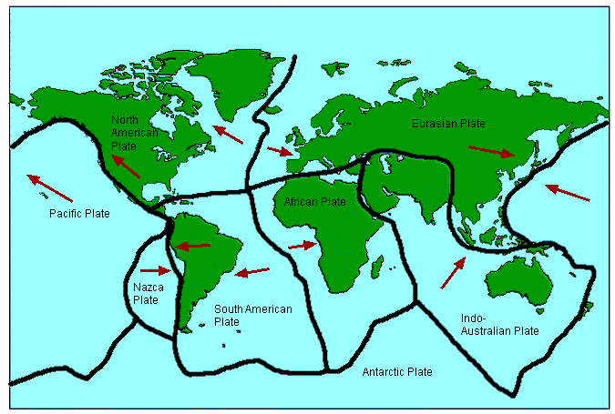
The theory of Plate Tectonics, as this new discovery was named, suggested that the crust of the Earth is split up into seven large plates and a few smaller ones, all of which are able to slowly move around on the Earth's surface. They float on the semi-molten mantle rocks, and are moved around by convection currents within the very hot rocks.
The plates are divided into two types; continental and oceanic.
Continental crust is made of older and less dense rocks such as granites. The most abundant minerals in continental crust are Aluminium and Silicon. From the chemical symbols of these two elements ( si and al ) a new name was created for these rocks, sial.
Sial is generally 35 to 70 km thick and mostly over 1500 million years old.
Oceanic crust is made of younger rocks like the ones found along the Mid Atlantic Ridge. The most common rocks are basaltic ones, which are more dense than the ones found in Continental crust. The two main minerals in these rocks are silicon and magnesium ( si and ma ), so this type of rock is called sima.
Sima is only about 6 to 10km thick and has an average age of a mere 200 million years.
How do the plates move?
The centre of the Earth is very hot, and some of this heat moves outwards into the mantle. This heating isn't the same all over the planet so some areas become hotter than others. Heat, like water, tries to level itself out, so heat energy moves from hot places to places that are cooler. As the rocks slowly move below the Earths surface, they drag the crust that lies over them. This causes the continents to move.
At the edges of the plates we see the ridges and trenches that gave the first clues to Plate Tectonics. There are a few rules that control what happens along these edges, or plate boundaries as they are called.

The rules of Plate Tectonics
1. Continental crust is less dense, or lighter, than Oceanic crust so it doesn't sink. It is never destroyed and is permanent.
2. Oceanic crust is heavier so it can sink below Continental crust. It is constantly being formed and destroyed at ocean ridges and trenches.
3. Continental crust can carry on beyond the edges of the land and finally end far below the sea. This explains why the edges of all the continents don't have deep trenches right up against their coastlines.
4. Plates can never overlap. This means that they must either collide and both be pushed up to form mountains, or one of the plates must be pushed down into the mantle and be destroyed.
5. There can never be gaps between plates, so if two plates move apart, as in the middle of the Atlantic, new rock will be formed to fill the space.
6. We know the Earth isn't getting bigger or smaller, so the amount of new crust being formed must be the same as the amount being destroyed.
7. Plate movement is very slow. This is partly why Wegener's original ideas were ignored. Nobody could 'see' the continents moving. When the plates make a sudden movement we call it an Earthquake, and it's the only time we are directly aware of the plates moving.
![]()
