The Earth was formed about 4.6 billion years ago, and its size hasn't changed much since then. We know that the plates are moving, and that in some places new crust is being formed. If the Earth is staying the same size AND more crust is being formed, that means that crust must be destroyed at about the same rate as it is being created.
The destruction of the crust takes place along plate boundaries where plates are moving toward each other, and creation of the crust occurs where plates are moving away from eachother.
This page explains the different types of plate margins, and gives a 'case study' example of each one.
Boundary Type |
Example |
Divergent
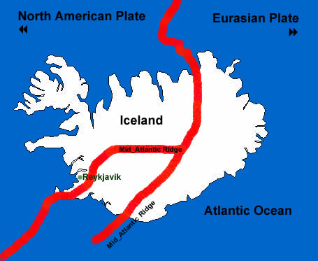
Divergent boundaries are found along spreading centers where the plates are moving apart. New crust is created by magma rising up from the mantle and constantly filling the gap created by the diverging plates. The best known example of a divergent plate boundary is the Mid-Atlantic Ridge.
|
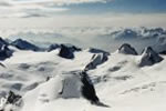
Case Study Mid-Atlantic Ridge The Mid-Atlantic Ridge runs from the Arctic Ocean, right down through the equator and on past the southern tip of Africa. The North American and Eurasian plates move apart at different speeds depending on the part of the boundary being measured, but the average rate of spreading is about 2.5 centimeters per year. That's about 25 km every one million years. Iceland lies across the Mid-Atlantic Ridge towards it's northern end, and becomes wider every year as the North American and Eurasian Plates drift apart. Parts of Iceland are spreading at 9cm per year. The volcanic activity is a tourist attraction and provides geothermal heating for water and homes. |
Convergent: Oceanic/Continental
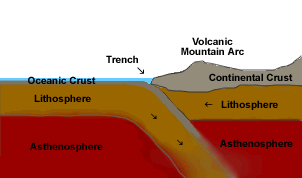
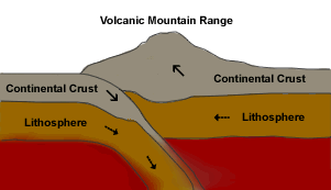
Oceanic crust is more dense than continental crust and, when the two meet, the oceanic crust is always the one that sinks, or is subducted. The Peru-Chile trench lies off the coast of South America, where the oceanic Nazca Plate is being subducted under the continental South American Plate. The continental South American Plate is crumpled and forced lifted up, creating the Andes mountain range. Earthquakes are common in this region, and are often violent and linked to sudden uplift of the land, sometimes by as much as several metres. Although the Nazca Plate as a whole is constantly moving and sinking, parts of it break and become stuck. Pieces that become stuck for long periods built up enormous stress. When they suddenly give way and move, they generate powerful earthquakes. Oceanic crust subducted into the Mantle is converted by pressure and heat into magma, which being less dense than the Mantle, tries to rise. Where it reaches the surface it forms volcanoes.
|
Case Study Nazca and the S. American Plate One of deepest and largest subduction zone earthquakes ever recorded in South America struck on 9th June 1994. The earthquake measured magnitude 8.3 on the Richter Scale. The epicentre was about 320 km northeast of La Paz, in Bolivia. The depth of the earthquake was calculated as 636 km below the surface, so it happened within the subduction zone. A 'quake of this magnitude could normally be expected to cause considerable damage, but on this occasion it's great depth meant that little surface damage occured. |
Convergent: Oceanic/Oceanic
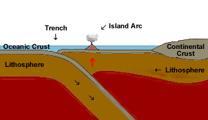
As with oceanic-continental convergence, When two oceanic plates converge, one is usually subducted under the other, just the same as when an oceanic plate collides with a continental one. As one plate is subducted a deep trench is formed on the sea bed. Magma rising up from the subduction zone leads to the formation of volcanoes. Given enough time (millions of years) the submarine volcanoes grow large enough to rise above sea level and become new volcanic islands. These volcanoes are often created along the plate boundary and their tops appear as a line of islands. These lines of islands are called island arcs.
|
Case Study Marianas and the Aleutian Islands The Marianas Trench, which runs parallel to the Mariana Islands, has formed where the relatively fast-moving Pacific Plate converges with the less speedy Philippine Plate. At nearly 11,000 m below sea level , the Challenger Deep, at the southern end of the Marianas Trench, is the deepest known point. For comparison, Mount Everest rises a mere above 8,854 m above sea level. Another example of an island arc are the Aleutian Islands |
Convergent: Continental/Continental
When two continents meet head-on, neither is subducted because the continental rocks are both relatively light. Since neither is significantly more dense than the other one they are both pushed up and/or sideways. The resultant folding and buckling creates fold mountains.
|
Case Study Himalayas and the Tibetan Plateau When modern India began to collide with Asia about 60 million years ago, a sea that had existed between then vanished as the land started to rise. The Eurasian Plate began to fold and buckles as it rode up over the Indian Plate. The plates have continued to convergence, pushing the sedimentary rocks of the ancient sea higher and higher until they formed the Himalayas and the Tibetan Plateau. The Himilayas continue to rise because the plates are still converging. |
Transform
A transform fault is a fault where two plates slide past eachother rather than hitting eachother head on. The area or zone between the two plates is called a transform-fault boundary, or transform boundary. Most of the examples of transform faults are out of sight on the sea floor where they are associated with active spreading ridges. Like other plate boundaries it's common to find earthquakes along transform boundaries. Unlike some of the 'quakes experienced on convergent boundaries, most quakes along transform boundaries are shallow. Only a few transform boundaries can be found on land, the most famous of which is the San Andreas fault zone in California.
|
Case Study The San Andreas fault The San Andreas fault zone is about 1,300 km long and in places is over 20 km wide. The mainfault cuts atleast 16 kilometers into the Earth's surface. Although we often associate the fault with San Francisco, it runs along two thirds of the total length of California. The Pacific Plate is slowly moving in a northwesterly direction at about 5cm per year, and has been doing so for atleast 10 million years. The North American Plate, on the eastern side of the fault zone, is moving in a southeasterly direction relative to the Pacific Plate. Earthquakes occur every day along the fault zone, but few are large enough to attract attention. In 1989, the Loma Prieta earthquake, that measured 7.2 on the Richter Scale struck San Francisco at about 5pm causing massive damage, killing 62 people and injuring nearly 4000 others. |
Plate Boundary Zones
Not all plate boundaries fit into the main groups shown
above. In some parts of the world the boundaries are not easily defined
because the deformation caused by the plates covers a wide area rather
than having clearly defined plate edges. This broad belt of deformation
is called a plate-boundary
zone.
The smaller fragments of plates are called microplates. |
Case Study Mediterranean-Alps The Mediterranean-Alpine region between the Eurasian and African Plates |
![]()