

|
|
|
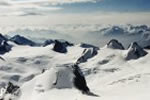
In highland areas the most obvious glaciers features are usually those created by erosion, not deposition. Features such as corries, ribbon lakes, U shaped valleys and hanging valleys are typical of upland areas such as the Alps in Europe, the English Lake District and the Southern Alps in New Zealand.
U Shaped Valley
When a glacier erodes its valley , a classic U shape is formed, the side walls tending to be steep and possibly curving inwards at the base, and the valley floor almost flat.
U shaped valleys often start life as river valleys that existed before glaciation occurred. The glaciers then followed the existing V shaped valleys, eroding and deepening them as the ice moved. Over time the valleys became straightened, widened and deepened, keeping the steep sides and acquiring a flat base. U shaped valleys are also known as glacial troughs.
The flat floor is roughly shaped by the ice which tends to cut down more evenly than flowing water. A thick layer of glacial debris (ground moraine) is deposited as the ice retreats, smothering any minor irregularities, and creating a well drained and fertile soil.
In mountainous areas, the low lying flat valley floors are frequently used for farming, transport routes and habitation. They offer the easiest routes through the mountains, are warmer than the higher ground, and have good water supplies. The flatness of the ground is particularly advantageous for rail and road systems where steep inclines are best avoided.
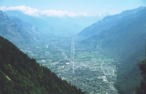
In the picture above, you can see a large habitation (bottom centre), almost dead straight road and rail routes running parallel to each other along the centre of the image from bottom to top, agriculture (fields in the middle to either side of the road/rail route), and truncated spurs (middle left).
Truncated Spurs
Spurs that projecting into the original river valley are cut short, their lower ends being destroyed by the moving ice. They may be cut back right to the edges of the new valley, or still project slightly into the valley. This shortens the spurs, or truncates them. They are then known as Truncated Spurs
![]()
We value
your ideas and suggestions. Please contact the
maintainer of this site.
This page
can be found at: http://www.geography-site.co.uk
Last update to
this statement was on:
February 23, 2006
© Copyright Geography Site