

|
|
|
Drumlins are formed of till. They are elongated features that can reach a kilometer or more in length, 500m or so in width and over 50m in height. One end is quite step, whilst the other end tapers away to ground level. The Stoss end is the steeper of the two ends and used to face into the ice flow.
The shape of some drumlins is somewhat similar to the ramp you might see being used to load large objects, like vehicles or pod storage units, on to platforms or big trucks for transportation.
The Lee slope is the more gentle slope and becomes lower as you move away from the source of the ice. This means that the highest point will always be at the Stoss end of the drumlin, and the lowest point will be the end of the Lee slope. It is common to find several drumlins grouped together. The collection of drumlins is called a swarm. Areas with swarms of drumlins are sometimes referred to as 'basket of eggs' topography because of the rounded bumps that remind people of a box containing eggs.
There is still some debate about how drumlins are formed, but the most widely accepted idea is that they were formed when the ice became overloaded with sediment. When the competence of the glacier was reduced, material was deposited, in the same way that a river overloaded with sediment deposits the excess material. The glacier may have experienced a reduction in its competence for several reasons, including melting of the ice and changes in velocity. If there is a small obstacle on the ground, this may act as a trigger point and till will build up around it.
It is difficult to understand how the material could have been directly deposited in the characteristic shape of a drumlin unless the ice was still moving at the time, but it may also have been reshaped by further ice movements after it was deposited.
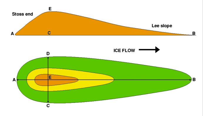
In the diagram above, the ice was flowing from left to right. The long axis of the drumlin is the line A-B, the point of maximum width is the line C-D, and the highest point on the landform is at E. Not all drumlins will show such a distinct difference in slope angle between the stoss end and lee slope, but the stoss end will always be the steeper of the two.
![]()
We value
your ideas and suggestions. Please contact the
maintainer of this site.
This page
can be found at: http://www.geography-site.co.uk
Last update to
this statement was on:
March 26, 2013
© Copyright Geography Site